File:SCSHmap.jpg

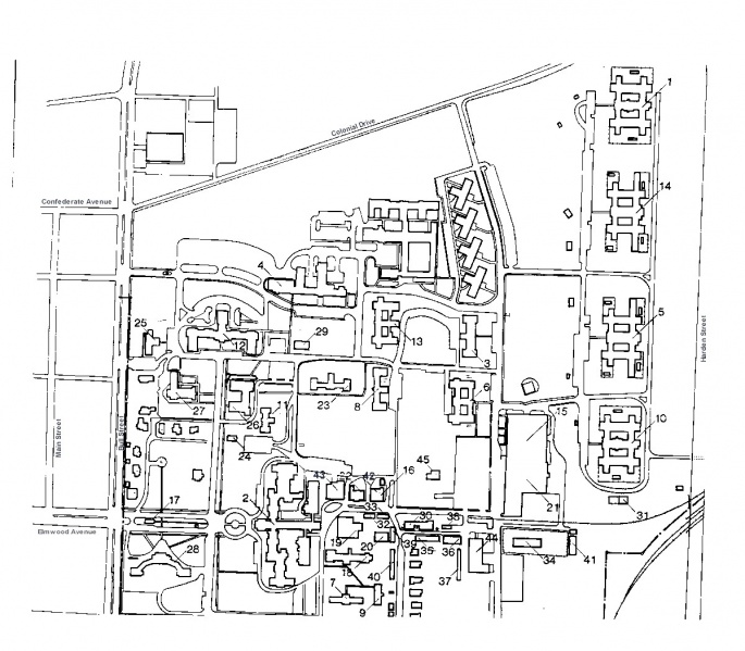
Building Locator Plan
Bldg. Name Bldg. Number Bldg. Name Bldg. Number 1 Allen 91234 24 Canteen 91217 2 Babcock 91201 25 Administration 91221 3 Blanding 91230 26 Benet/Horger 91219 4 Byrnes 91224 27 Chapel 91218 5 Cooper 91236 28 Mills Bldg. 91244 6 Gibbes 91231 29 Ensor 91223 7 Laborde 91202 30 Boiler Plant 91243 8 Leiber 91232 31 Energy Fac. 3 91211 9 Parker Annex 91203 32 Stor. Bldg. 1 91070 10 Preston 91237 33 Stor Bldg. 2 91071 11 Trezevant 91215 34 Salvage Shed 91010 12 Williams 91220 35 Carpenter Shop 91007 13 Wilson 91233 36 Welding Shop 91008 14 Saunders 91235 37 Lumber Shed 91047 15 Food Center 90238 38 Paint Shed 91012 16 Second Hd. Stor.91210 39 Stor. Shed 91044 17 Security 91045 40 Multi. Garage 91053 18 Parker 91204 41 Greenhouse 91240 19 Clean Linen 91205 42 Yard Stor. 91209 20 Soiled Linen 91206 43 Ice Cream Plant 91212 21 Warehouse 90239 44 Maintenance Bldg. 91242 22 Old Bakery 91213 45 Mattress Shop 90241 23 Thompson 91217
File history
Click on a date/time to view the file as it appeared at that time.
| Date/Time | Thumbnail | Dimensions | User | Comment | |
|---|---|---|---|---|---|
| current | 09:39, 13 January 2012 |  | 1,200 × 1,050 (297 KB) | Soldat251 (talk | contribs) |
- You cannot overwrite this file.
File usage
The following page links to this file: